Hi and welcome to the third installment of this blog. I hope you’ve enjoyed reading and watching the first two so far but this one is going to be run a bit differently. For the third assessment of Ecological Engineering I (or rather I should say my whole class) was challenged to create a blog post, with an accompanying vlog, that had input from everyone in the class. Please note here: This is a class of over 40 people.

For this whole class project, we were tasked to do a case study of Hurricane Katrina. In the process of analysing the disaster we were to apply every ecological principle that we had learnt about in the class. Although faced with a few challenges (it’s not always easy to contact over 40 university students at any given time), we came together in the end to produce this post.
We all hope you enjoy reading through our individual thoughts on the Hurricane that devastated New Orleans and learn something new in the process. Please click on the read more below to see the rest of the post.
Before completely diving in, I’d like to offer you an insight into how we have structured the blog. When brainstorming for the post, we noticed that a lot of questions were popping up over and over again. Once a list of these commonly occurring questions was put together, the class noticed that the number of questions roughly matched how many people had to write a section. Perfect!
At the end of this post will be the vlog, made by the other half of the class (another momentous effort).
If the blog seems a little bit disjointed at times, take it as a sign of the wonderfully different ways that people choose to communicate and present their ideas. For the first question we’re starting you off at the very basics of Hurricane Katrina. Enjoy and make sure to check out our “Making of” blog next!
What Is the History of New Orleans?
In the late 1600’s a Frenchman named Robert de la Salle claimed a large section of what is now modern day North America, naming it Louisiana. In 1718 the governor of Louisiana, a gentleman by the name of Jean-Baptiste Le Moyne, Sieur de Berville was responsible for the establishment of New Orleans. Berville had found a bend in the Mississippi River that he believed would be ideal for a settlement, ironically due to his belief the crescent river bend would shelter the town from hurricanes and tidal waves (the town was also in a strategic position to guard the mouth of the Mississippi River). He then proposed the idea to the Mississippi Company (a French corporation that had business control over all French colonies in the West Indies and North America) and construction commenced. Adrien de Pauger was the engineer responsible for setting the town out in a grid pattern, after the first attempt at a settlement was heavily damaged by (guess what?) a Hurricane.
After the War of 1812 between the United States and Britian, the City of New Orleans prospered as the second largest port in the USA. By 1840 New Orleans became the fourth largest city in the country.

What Is New Orleans Like Now?
New Orleans focuses on tourism, transportation, and gambling as its economic backbone. New Orleans operates one of the world’s largest and busiest ports and metropolitan New Orleans is a center of maritime industry (later explored as to the existence of channels and levees).
The region accounts for a significant portion of the nation’s oil refining and petrochemical production. In 2013, New Orleans had a GDP of more than 180 billion U.S. dollars. It was the most economically developed city in the state. The population of New Orleans is 378,715 (2013), and the population of the metropolitan area is 1,240,977 (2013). The population of New Orleans is now dominated by African Americans.
New Orleans was hit by Hurricane Katrina in August 2005 and suffered heavy losses. As a result, the population has dropped dramatically. Following Hurricane Katrina in 2005, residents have migrated from New Orleans. Now, the city with a population of only 370,000 people.
How did Hurricane Katrina Happen?
Katrina was the 11th tropical storm in the hurricane season of the year 2005. It initially formed from the interactions of a tropical wave and the remnants of a previous tropical depression on Aug 23, 2005. One day later, Katrina turned westward towards Florida, in which, it made its first landfall. Upon landfall, it was classified as a moderate Category 1 hurricane. Katrina then only took 6 hours over land and arrived Gulf of Mexico on 26 Aug, which it gain strength and became a Category 5 storm in Aug 28 (see below image for comparison), with peak winds blowing at 175 mph. Then Katrina weakened rapidly to a Category 3 storm before making landfall along the Louisiana-Mississippi border on the morning of Aug. 29.

What Were the Consequences of the Hurricane?
Here is a quick video from YouTube recapping these facts.
Hurricanes are always accompanied by some serious problems, such as economic, environmental and even death. During the past century, hurricanes have flooded New Orleans six times: in 1915, 1940, 1947, 1965, 1969 and 2005. However, of these, Hurricane Katrina, was the most costliest deadliest hurricanes ever to hit New Orleans. By August 28, approximately 1.2 million people evacuated the New Orleans region due to the National Weather Service predicted that after the storm pass through,
When the storm surge made landfall, it overwhelmed many of the city’s unstable levees and drainage canals. Thus, by the time Hurricane Katrina passed, although CBD and main tourist centres were relatively undamaged, around 80% of New Orleans and its neighbour area were flooded, which the most serious area was more than 4 meters deep.

Moreover, Hurricane Katrina and the subsequent flooding lead to 134,000 house units being destroyed. Hurricane Katrina damage costs resulted in around $135 billion, while insurance covered only $80 billion of these losses. However, further study has suggested these costs could be even higher at around $250 billion, when considering damage and economic costs.

The hurricane not only took away people’s property but also their lives. More than 1800 people lost their lives in the massive storm and in its immediate aftermath. Sadly, it was the some of societies most vulnerable with half of the victims over the age of 74. Truly though we will never know the actual number as many bodies were flushed into the ocean.
Beside the impacts mentioned above, Hurricane Katrina also impacted the environment. For example, Lake Pontchartrain may have been permanently damaged due to the Hurricane Katrina. Water needed to be pumped back into the lake to get the water out of the flooded New Orleans. But the water was contaminated by the bacteria from decomposing bodies, oil and chemical, etc. And it definitely had negative impacts for the ecosystems involved in the lake.
What Are the Long Term Consequences of the Hurricane on New Orleans?
The scope of hurricane disaster has a wide range of impacts, making post-disaster reconstruction extremely difficult. Survivors suffer from bereavement and their life suddenly became extremely poor and difficult, affected communities are in a mess and unrest, New Orleans governments are faced daunting task with recovering and rebuilding destroyed economy and social assets.
After hurricane, the New Orleans becomes very unstable and the crime rate rises, with extensive reporting of looting, violence, shooting against rescuers, murder and rape. Under very few supplies, survivors scavenging necessary supplies such as food, water, clothing, and shelter. At the same time, the government is in trouble, additional acts of unrest occurred following the hurricane, particularly with the New Orleans Police Department, almost one-third of New Orleans police officer deserted the city, many of them escaping in their department-owned cars.
Social chaos has led to difficulties in search and rescue work, the government has to put more force to reduce the crime rate. On August 31, New Orleans’s 1,500-member police force was ordered to abandon search and rescue missions and turn its attention toward reduce the crime events. In addition, the Louisiana State Guard and State Defense force from several states had arrived in New Orleans to help the large number of survivors escaping and assist in other disaster recovery operations.
The prolonged flooding after hurricane can cause health problems, the rate of dehydration and food poisoning is high and there was also potential for the spread of hepatitis A, cholera, tuberculosis, and typhoid fever. In addition, due to prolonged exposure to the contaminated flood water and mosquito-borne diseases, survivors will face the long-term disease problems.
Why Did Hurricane Katrina Hit the City So Hard?

There are many reasons to this occurring. However, here are some quick summarised points relevant to know before diving into our proposed solutions
- The lack of barrier islands and wetlands allowed the tidal surge to attack the levees at full strength
- Hurricane protection management policy: poor risk management approach, uncoordinated construction, maintenance and operation of levees, and also no levee subsidence correction programs
- Inadequate emergency response: lack of a mandatory evacuation order, unprepared local and state emergency response agencies and a late national response.
- Lack of funding for the wetland restoring project.
- Sediment losses due to Katrina
- The construction of levees were not up to standards with compacted clay cores and surface protection, and they were constructed by filling with hydraulic dredged materials taken from channels along the levees, namely sand and shell materials which are highly vulnerable to erosion. The failed levees created a holding area for the over topping water to fill beyond capacity and thus over topping the interior levees further.
- The floodwalls failed principally due to under-seepage flows that passed beneath the sheetpile curtains supporting the concrete floodwalls at the crest of the levees (deflection of the floodwall as water levels rose, allowing high hydrostatic pressures to reach deep into the foundation of the walls). Those sheetpiles were too shallow to adequately cut off the under-seepage flows.
- Overtopping caused scour on the protected side of the floodwalls leading to a loss of supporting earth for the floodwalls. In addition, the supporting ground on the protected side was considerably lower than the channel side.
- The pumping stations were simply flooded during the hurricane and not protected plus lack of back power and no evacuation of operators. Only 16% of the total pumping capacity for the region was operable during or after Katrina.
- There were no flood gates installed on any of the canals.
What Is the Rate of Destruction of the Wetlands and Is It Still Being Destroyed?
Wetlands along the southern coastlines of the United States serve as natural speed bumps to approaching hurricanes by starving them of warm ocean water and creating physical barriers to surging floodwaters. However, in the last 100 years, the construction of levees and canals has turned thousands of square miles of wetland habitat into open water.

According to the U.S. Geological Survey (USGS), an average of 34 square miles of South Louisiana land, mostly marsh, has disappeared each year for the past five decades. As much as 80% of the nation’s coastal wetland loss in this time occurred in Louisiana. From 1932 to 2000, the state lost 1,900 square miles of land to the Gulf of Mexico.
An alarming 50% of the world’s wetlands have been destroyed in the last 100 years, threatening human welfare at a time of increasing water scarcity. Wetlands serve as a source of drinking water and provide protection against floods and storms, yet they have been decimated to make space for housing, factories and farms or damaged by unsustainable water use and pollution.
Today, wetlands degradation and destruction is occurring more rapidly than in any other ecosystem. Half of the world’s wetlands have disappeared since 1900. Development and conversion continue to pose major threats to wetlands, despite their value and importance.
By 2050, if nothing is done to stop this process, the state could lose another 700 square miles, and one-third of 1930’s coastal Louisiana will have vanished. Importantly, New Orleans and surrounding areas will become ever more vulnerable to future storms.
“New Orleans can’t be restored unless we also address coastal and wetland restoration too,” says Craig E. Colten, a geographer at Louisiana State University (LSU).
What Caused the Destroyed Wetlands and What is the Land Being Used For Now?
Louisiana’s wetlands are water saturated swamp and coastal regions of southern Louisiana, largely along the flow and delta region of the Mississippi river as it empties into the Gulf of Mexico. For centuries, the flow of the river conveyed tonnes of soil and silt to the coast each year, a natural cycle of wetland flooding and replenishment was in place. The wetlands protected New Orleans against hurricane storm surges, soaking up the surging waters like a sponge.
However, since around the turn of the 20th century there has been a remarkable disruption in the hydrology of the river system causing the wetlands to be destroyed. This destruction is mainly attributed to the creation of flood levees and canal dredging for oil and gas exploration and extraction, which have kept the river from flooding starving the wetlands of new soil and nutrients and causing them to disappear at an alarming rate.
Oil and gas exploration and pipeline placements are responsible for the direct and indirect removal of Louisiana wetlands. Almost 100 oil and gas companies have been recently sued by the Louisiana Levee Board for the erosion of the wetlands. The companies include well know names such as Shell, BP and Chevron. It is likely most of these companies are or belonged to the original “Seven Sister” oil and gas companies: Anglo Persian Oil Company, Gulf Oil, Texaco, Royal Dutch Shell, Standard Oil of New Jersey and Standard Oil of New York.
While small encroachments of suburbia and civil works have also taken over parts of the depleted wetlands with the natural expansion of cities and towns in Louisiana, the degraded regions remain largely uninhabited.
Who Had and Currently Has the Power to Make Decisions For the Wetlands?

The Flood Control Act of 1928 was passed by the 70th US Congress and allowed US Army Engineers to construct levees to control floods of the Mississippi river. The act was deemed a necessity after the Great Mississippi Flood of 1927 which had devastating effects. The act of setting levees unfortunately reduced the amount of freshwater sediment being transmitted to the downstream wetlands.
Ultimately the Louisiana Department of Natural Resources has the ability to enact the rehabilitation of the New Orleans Wetland Delta. The department working together with the New Orleans District, U.S Army Corps of Engineers is able to carry out the repair of these natural systems as part of the Louisiana Coastal Master Plan. Whether or not they will and by when is another question though.
Does Wetland Destruction Happen Throughout the World? What can we learn (or unlearn) from them?
In history and some other parts of the world, the damage of wetlands is very common.
In the northeast of China, there used to be a beautiful wetland. In fact, this wetland area was the first in Asia. Imagine endless reeds, countless water birds, fish, shrimp and crabs, all of which provide a lot of living resources for the local residents.
But in the fifties and sixties of the last century, due to the policy and the growth of population, a large number of workers and peasants migrate into northeast China wetland and turn the wetland into farmland. This wetland has been greatly damaged. The wetland area has decreased, the water quality has been polluted, and the biodiversity has decreased. In 2000, the Chinese government proposed a new policy to stop the development of the northeast wetland.

Dongting lake was China’s first big freshwater lake, grain enjoy the reputation of “land of fish and rice” the height above an area of 6000 square kilometers, but over the past century, under the dual role of nature and human activities, lake area is shrinking, has been relegated to the second largest freshwater lake in China. According to the records, the area of dongting lake was 6000 square kilometers in 1852.As a result of siltation and human activities, the area was reduced to 4,350 square kilometers by 1949. In the next 30 years, due to extensive development, by 1995, the area was only 2,623 square kilometers.
Is Wetland Conservation Incorporated into the Future Plans of Louisiana?
YES (thankfully).
6 years later after Hurricane Katrina plowed into New Orleans and the Mississippi River delta, a new plan called Louisiana’s Master Plan for avoiding the tragedy happening again from future storm had been made, which mainly depends on the wetland restoration. The authority’s most recent framework, released in 2012, projects that it can halt the loss of land in 20 years and build or sustain up to 800 square miles of wetlands and barrier islands, another important defence, over the next 50 years.
Louisiana’s Master Plan for the Coast includes projects like marsh creation, sediment diversion, levee, structural and shoreline protection, hydrologic restoration, and oyster reef restoration.
The plan is ambitious and, if implemented on time, can restore and save some crucial wetland areas (in yellow and green), but some regions are sinking too quickly and will be sacrificed (in red).

The more difficult, but possibly more effective, route is to mimic the natural process through which the Mississippi created land over the past 7,000 years. “Sediment diversion” entails controlled flooding that allows the river to deposit silt in surrounding areas. The state would essentially cut through natural levees and replace their earthen material with gates to allow some water to pass through. “Channel realignment” would go one step further, redirecting the river in a wholesale fashion. The CPRA proposal argues that “sustainable restoration of our coast without sediment diversions is not possible”.
Can We Learn From These Mistakes Before They Happen?

Hurricane Katrina was by no means a surprise to the world which watched the devastation unfold. The inadequate protective infrastructure, flaws in emergency response planning and especially the destruction of the natural barriers (wetlands) were all documented and known about.
It’s the age-old question, why do we only act afterwards? Why does it take loss to awaken us to the need for action?
It’s something we are so familiar to.
It takes the failing of a unit to motivate us to prioritise our studies, the inability to handle a short sprint to catch the bus to show us our need for exercise and even the death of a loved one to remind us to speak our hearts more often.
Is this just inevitable? It can seem that way at times. Often it takes what is called “focus” events for change to occur. In essence, events occur that focus our pre-existing (yep, we already knew about it!) ideas to be revamped. Because truly, there are few new, unheard of problems out there that we face. I mean think about it, how many issues around the world occur due to totally unknown factors? Not many! We know about and are very familiar with the root causes.
We are plugged into (continuously) the bombardment of information of what is going on around this earth we spin on. How can our attention to so many causes possibly be focused and prioritised? How can our governments who so often drive the change behind environmental projects do that very thing?
We must understand that our governments and social systems show restraint towards change that would address known issues. They handle the consistent tension between adaption to new technologies, processes and ideas that are being created but also maintaining what has “always worked before”. Stability and the resistance to “jump ship” at every new event is built into these systems. This is neither entirely positive or negative.
Stability is protective.
Stability is condemning.
Both, at the very same time.
What is created after an event is a very small window of opportunity. Mass media attention in response to the event salience stimulates a communal “why did this happen?”. This opportunity must be seized. Major advocacy coalitions must capitalise on the momentum created to gain policy reform necessary.
Hurricane Katrina is not a distant memory, but its possible that such momentum has slowed over the years making it difficult to push for our ideas presented here. It’s important for us therefore to be aware of this and link the delivery of our proposal with more recent yet similar natural events occurring. Understanding the power of focusing events could very well help us achieve a safer and more restored future.
What Ecological Ideas Have Been Implemented Around the World?
Considering the significant importance of wetlands, which not only could be used for flood protection and shoreline protection, but also it effectively protects the wildlife & habitat and controls the erosion, many authorities have already taken actions to protect, restore and explore wetlands.
For example, American government develops the Wetland Program Plans in early 2000, and luckily some wetlands make a considerable difference to storm & flood protection and significantly minimize the property damages (like the wetland reduced damages to New York and New Jersey during Hurricane Sandy). Similarly, 9000 hectares of mangrove wetlands in Vietnam brings lots of benefits in policy and practice. Besides, in Netherland, whose elevation is much lower than seawater level, the authority advocates the Delta Works, which is regarded as one of the Seven Wonders of the Modern World, and it plays a crucial role in shorting dikes, providing fresh drinking water and irrigation and improving traffic movement between various islands. With regard to the project, sustainable development is widely promoted, like generating electricity through tidal power and wind power to satisfy the electricity needs of local people.
Obviously, learning and analysing the previous natural disasters and related projects represent the most effective way to gain improvements. Take the 1953’s massive flood and the Delta Works as an example, it is our human nature to want to return to the status quo after the disaster, and once we realize the disastrous result and learn the lesson for the disaster, we will be well prepared and prevent the disaster in advance. More specifically, public education and awareness for disasters should be strengthen by governments through online safety courses, TV show, safety brochure, school education… While for officials and engineers, post-disaster projects or rescue work would be good examples to learn, like the Maeslantkering storm surge barrier has also been applied to several other locations in the world (storm surge barriers in New Orleans).
What Are The Ethics of Ecological Design?
In modern design, due to the severe situation of natural resources crisis, respecting nature has already been endowed with new meaning. In ecological design system, the base goal is to solve the problem of the contradiction between man and environment, which is becoming more and more serious by pursuing of “natural beauty”. Based on that, the society can ultimately achieve the goal of sustainable development.
Due to the close relationship between modern design and environment, design cannot finish design creation by itself, modern design must take a positive attitude to implement design coordination with the environment, from that, it can arrive the ecological culture. Therefore, under the background of modern design, strengthening the moral status of ecological design in modern design, making it real is absorbed by modern design ethics and guiding the design practice have a great significance for the sustainable development. At the same time, in reality sense, the ecological design did meet the requirements of humanization design, which has started from the basic moral of humane design theme, by coordinating the relationship between society, economy, environment and design.
In my opinion, ecological design morality should pay most attention to establishing a sense of respect, which is respectively to respect nature, life and knowledge.
How About Some Inter-generational Fairness?
The role of current generations in providing a sustainable future for future generations is currently a hot topic. The topic has reared its head in many issues, from housing affordability, pollution, and of course in the effects of climate change. This concept is tied into the notion of inter-generational fairness, the idea of fairness or justice between generations, be it between generations currently living and also future generations yet to be born. It circulates around the idea that previous and current generations have benefited themselves and unfairly left the economic, social and environmental consequences to be shouldered by future generations.
While it’s hard to pin the obligation to provide a sustainable future as a legal obligation to the current generation, it is certainly reasonable to pin it to an ethical obligation. With the knowledge we now have on some of the underlying causes of the devastating effects of Hurricane Katrina on New Orleans, we should bare an ethical obligation to provide solutions to prevent a repeat, both now and in the future.
Great! We’ve learnt a lot now. Hopefully a lot of your questions about Hurrican Katrina have been answered.
But! There is still an important area that we haven’t covered. We know whats has happened in the lead up to Hurricane Katrina, but what can we do going in to the future?
Here is where our chosen solution comes in. Welcome to part two of the blog:
SPONGE CITIES!

(not that kind of sponge)
Sponge cities is not only a catchy name, but an effective solution at mitigating the effects of flooding. Read on for more info!
Wetland Restoration
Restoring the Mississippi River Delta will take a main part of the project. This includes the reintroduction of fresh water and sediment to the costal system relate to the ecosystem. Let’s see the idea from San Francisco Bay wetland restoration program.
They have a concept which is called -The horizontal levee. This idea is trying to use the tidal marshes to reduce the destructive forces of storms. The typical flood prevent system in New Orleans was constructed the levees close the offshore. It stops floods, it also means less silt and soil to the wetlands. For the horizontal levee, it abandons offshore levee, incorporates a brackish marsh at the landward edge of typical tidal marsh restoration designs. The brackish marsh has a function of levee, building in elevation as plant root systems expand. It accelerates vertical growth of the marsh plain in order to keep pace with sea level rise. It is good nature defence to the flood.
After the brackish marsh, it also has freshwater swale, which store a lot of water. This wastewater can be returned to the plant for more treatment.
Benefits
- The horizontal levee can reduce a lot of wave energy of storms
- It can reduce the cost of flood protection system with less levees
- It can reduce the worries about the global warming.
- It can enhance escape options and survival rates during flood events.
- It can recover depleted habitat for wildlife.
Disadvantages
- Takes a long time to complete the construction of the horizontal levee system
- The marshes in Orleans are disappearing fast a football field’s worth is lost every hour. It needs more effective methods to reduce the vanished wetlands.
Natural Flood Defence
Our proposed solution is to also develop a hybrid model which includes a small dike and a buffering layer of tidal marsh. We like this idea as it has been demonstrated that shoreline flood protection is enhanced when areas of tidal marsh lie between the coast and the sea.
But if you don´t believe it, let´s look at some benefits it produces. The tidal marshes can reduce wave energy in severe storm events by over 50%. Furthermore, studies have proved that by a adding a layer of tidal marsh a smaller dike is required in order to give the same protection against sea level rise and storms.
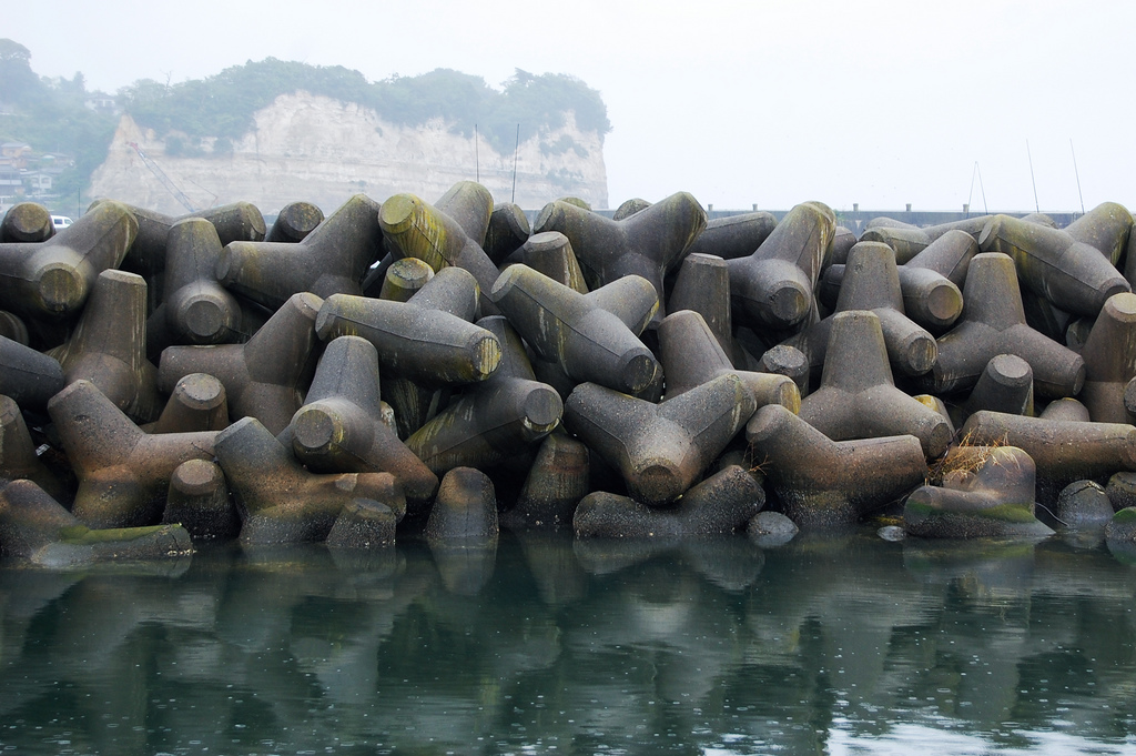
Tetrapods Defence System
Here we go, slam-dam super jam idea number 3 coming at you.
Tetrapods
Tetra-wods?
Other than the biological description for a four footed vertebrae, in engineering Tetrapods are a type of structure in coastal engineering used to prevent erosion caused by weather and longshore drift, primarily to enforce coastal structures such as seawalls and breakwaters. Tetrapods are made of concrete, and use a tetrahedral shape to dissipate the force of incoming waves by allowing water to flow around rather than against them, and to reduce displacement by interlocking with each other.
As engineers in this situation we are concerned with two ideas:
- Protect the city from storm surges
- Help the environment regrow and act as a natural barrier
New Orleans is not alone in this situation. We can look to the coastal cities of Japan, which in recent times have been battered by storms, floods and in the worst case; Tsunamis. However, no disaster has had a big of an impact on Human Life as Katrina did on New Orleans, which is an amazing feat considering the Fukushima Daiichi Nuclear Power Plant Disaster in 2011. So how does Japan contain the massive volumes of water that come with these powerful storm events? Ya guessed it! Tetrapods!

(Very Japan looking isn’t it?)
Other than the biological description for a four footed vertebrae, in engineering Tetrapods are a type of structure in coastal engineering used to prevent erosion caused by weather and longshore drift, primarily to enforce coastal structures such as seawalls and breakwaters. Tetrapods are made of concrete, and use a tetrahedral shape to dissipate the force of incoming waves by allowing water to flow around rather than against them, and to reduce displacement by interlocking with each other.
Why is this better than a seawall?
As opposed to a solid sea wall or even natural breakwater, the design of tetrapods to be interlocking allows water and sediment to be carried through, whilst dissipating the force of the water crashing into them. Acting almost like a well-designed car bumper, rather than taking the full impact of the wave, these structures absorb the full force and allow engineer greater control over the flow of water. In New Orleans this is the ideal solution to letting sediment from the Mississippi to encourage the rehabilitation of sandbanks and mangroves as well as reducing the power of any storm surges coming into the city due to the advent of a hurricane.
Over 50% of Japan’s Coastline now has some sort of tetrapod structure helping in protection of the cities and ecological systems in these regions. Show below is a potential arrangement of tetrapods (in red) that can offer protection to the city of New Orleans as well as encouraging restoration of the wildlife management area inclusive of sandbanks and mangroves.
As said before this is only part of the solution as we look to transform New Orleans into a Sponge City; a city capable of proactively absorbing the effects of a stage 5 Hurricane whilst minimising impacts to residents given a worst case scenario.
Drainage and Pump systems
Flooding is a natural and inevitable part of our weather cycle. One way to minimising the risk to people, property and infrastructure can be achieved through planning, building and managing flood drainage and pump systems. The drainage systems built as part of early developments were incapable of holding large volumes of water. When there is more runoff than underground drains can carry, water can overflow onto surrounding land, flooding roads and properties.
So, how can we improve the drainage systems of New Orleans to prevent the raising flood waters after a hurricane. Two ideal types of drainage can be considered as solutions. One being the “French” drain design which directs the surface run off water and groundwater away from the home’s foundation or affected area.]

We have learned that the soil that the city sits on aren’t extremely strong and excess moisture from the floods will weaken it over time. This type of systems is ideal for the city’s situation considering it reduce the hydrostatic pressure and remove excess moisture from the soil by collecting surface and groundwater. French drains are usually installed below the vulnerable areas to ensure the hydrostatic pressure is reduced.
Infrastructure and City Planning To Mitigate the Effects of Cyclone
Fortunately, we have enough technology to predict the natural disasters yet failing due to not precise in locating the affecting regions.
In any difficult situation anybody on this planet have only two choices either to manipulate it or to get accustomed to it. It is stupid to think that you can build a strongest infrastructure which can face the strength of natural disaster. But we can mitigate, taking help from the nature, the impact of it.
Infrastructure:
From the past incidences we need to admit that it is not the cyclone’s strong winds alone which contribute to the majority of loss but the after effects. The very basic needs of any living beings in the time of crisis is to have sufficient food for the entire period of isolation and shelter from the strong winds and rains. These shelters need to be built in sufficiently elevated places underground which are fully equipped to supply enough running water from underground storage tanks for the entire period of cyclones.
Mitigation:
Coastal areas the most low-lying regions which are susceptible to damage for any little changes in atmospheric conditions. The effects of cyclone apart from strong winds are flood water and weakening ground strength due to absorption of flood water. Redeveloping the ground is the best investment which will foster the building structures and tress which will be planted densely which can absorb the shocks due to strong winds and protection from debris which become missiles associating with high speed winds.
Some guidelines of planting for cyclones:
- Choose trees with known wind resistance,
- Maintain their health,
- Do not plant big trees close to the buildings as their dense roots may disturb the foundation of the buildings,
- Ensure, plants have chance to develop deep roots and let the roots grown in all directions giving better stability,
- Avoid plants with shallow roots,
- Plant in clumps and bands not in rows,
- Prune out the really old trees to avoid weak branches becoming airborne.
Relying on animals for predictions:
It is not uncommon that people had noticed and recorded abnormal behaviour of animals few hours before natural disasters and there have been few examples from China which takes animal warnings seriously and helped prevent severe loss from earthquakes when scientists were able to predict the affected locations. this procedure could be well developed at least as a warning for a disaster and helps to alert meteorologists and emergency services for further actions
Education of the Masses (Worst Case Scenario)
A great project needs public involvement and iteration. Moreover, in this case, floods would influence each area of New Orleans; an overall strategy for a public participation program needs to be established to gauge the requirements of the citizens who would be affected.
Public-Private Collaboration
Adapting interdisciplinary approaches, moving away from silo-ist, isolated thinking. A common vision aligned engineers, hydraulic experts, GIS and information technologists, architects, planners, biologists, economists, communication specialists, and landscape architects with local citizens, investors, and politicians.
Moreover, solutions are often left out of upstream area planning where residents see no flooding problems. Yet water has no boundary. Municipal borders must be lowered to develop a shared vision across different districts. For example, can generate an interactive workshop which led by engineers and experts in a suburb, it can be used to enhance public awareness, engaged residents through a series of interactive sessions designed to raise awareness and survey desired citizen interests.
Using a visible public education tool or a demonstration area
For example, Green Streets and Guangming New district demonstration area. Green Streets utilize lowered street profiles to create a ‘Safety Zone’ and a ‘Flood Pathway’ corridor. Shared public spaces integrate pedestrians, cyclists, motorists, and alternative transportation along a common public realm. Solutions are visible public education tools.
A demonstration area will be set up to enable the public to learn about the implementation of the Sponge City project and its specific utility through the demonstration area. Taking the Guangming New district demonstration area as an example, this community is one of the Sponge City demonstration sites in China. Through this successful case, it has achieved public promotion and public educating.
Evacuation Solutions
When a powerful hurricane is approaching, the best choice is very simple; it is to “RUN” as fast as you can. However, there should be a plan for you and your family before you move to a safe place. The first thing is to find location to go to and how to get there. It might be considered not that difficult to find several places which are deemed safe. But the choice of the route taken to the evacuation location is not that easy. You may need to pass through areas which you are not familiar with to reach the destination. Sometimes, the maps cannot give you all the information that is necessary, for example, the condition of the road, it may be blocked by rocks or woods when you are trying to evacuate. Thus, it is important to ask the local community when planning for evacuation; the local residents know more detail about which path is more reliable. Information from official agencies such as governments and local councils is significant.
The concept of a Smart City (but we gunna still call it a sponge city just FYI). A Smart City is a city that integrates social development, capital, public participation, and transportation with the use of information technology to support the preservation of natural resources and improved quality of life. The idea suggests a creative way of thinking by using Geographic Information System (GIS) to make use of geospatial information to encounter natural disasters. Geospatial information is geospatial data that has been processed and can be used to facilitate planning, decision-making, and activities relevant to the detection of natural disaster sites. It is considered that GIS and mobile systems can enhance disaster management which includes preparedness, mitigation, response, and recovery from natural disasters.
MobieGIS provides real-time visualisation of spatial risks and resources and analyses the most suitable evacuation routes to safe locations. The concept of Smart City is primarily based on the analysis of real data to create action.
The Importance of Information for Evacuations
In the process of planning, the vulnerable communities should be given special consideration as they need more help than others. In Cuba, the local government collects detailed information to identify which of its citizens need special services. The doctor in each community knows who requires assistance in the neighbourhood; and the representatives or doctors will check whether vulnerable people need any precaution when the hurricane is approaching.
Sometimes, a small group of people are unwilling to evacuate because they are worried about their possessions. Usually, for them a powerful hurricane may destroy everything they have; thus, they are reluctant to follow the evacuation order. A unique solution of Cuba is that the public officials and the military will help these people to move their belongings to a safe place. Through this method, people, especially the poor will decrease their anxiety and concern about their properties.
Moreover, updating the evacuation plan regularly is significant, due to continuous change. I believe that accessing updated information is vital for the success of this idea. Through the information, we may find the optimum evacuation route and make it easier to figure out the category and quantity that we need when carrying out evacuation plans.
Cost Analysis (Show me the money!)

The development cost of sponge city is mainly concentrated in two aspects: the initial investment and construction cost and the later operation and management cost.
1. Capital demand for initial Construction of Sponge City
Sponge City’s initial capital needs are huge, only according to Chinese statistics, the construction costs ranging from 1.56 to 2.35 million dollars per square kilometre, Meanwhile, it is predicted that by 2020, more than 20 percent of China’s 658 urban built-up areas will meet the design standards of sponge cities, and China’s annual investment is expected to exceed 62.6 billion dollars. By 2030, more than 80% of the urban built-up area will need about 2,504 billion dollars to meet the target.
2. Cost of Operation and Management of Sponge City
In late stage Sponge city construction project actual benefit exertion, is restricted by the later stage operation management. Whether it is a small, decentralized low-impact development facility, or a large Rain Water wetland, multi-function water storage facilities, if it lacks late management and maintenance or mismanagement, not only its function cannot be effectively brought into play, but water pollution may even occur. Water damage, Rain Water resource waste and other phenomena. Therefore, the maintenance and management of real-time, scientific and efficient in the phase of operation and management is very important. As a new concept of urban management, one of the outstanding advantages of intelligent city is to realize convenient, fast, intelligent and efficient management of the city.
At the same time, we should actively promote the cooperation between the government and social capital, such as Public-Private-Partnership (PPP) model, franchising, etc., and attract social capital to participate extensively in the spongy city construction. PPP model is well used in infrastructure, such as sewage treatment projects. Each year, the government returns services to investors as part of public spending, which is mature. But, “how does the PPP model count public services in Sponge cities?” It is not as clean as a ton of sewage and is easy to calculate. Spongy cities are the equivalent of building an ecological green space system. How this part of the service is calculated is still a challenge.
The Most Cost-effective Solution
Financing is the potential stumbling block. Just because sponge city projects have the potential to be cost effective does not mean that funding them will be easy. China’s central government is providing a significant amount of funding for the pilot cities, but the subsidies are far from enough to fully fund sponge city construction. Estimates suggest that sponge city construction could require investments of RMB 100 million to 150 million per square kilometre, while the total area under construction in just the first 16 pilot cities is more than 450 square kilometres.
Sponge city is a type of low-impact development, (LID is an eco-technical system that can easily achieve urban rainwater collection and utilisation). When constructing sponge city, it is necessary to consider not only ecological elements but also cost considerations. Here is an effective way to build sponge cities in cost-effective.
Mainly to transformation, supplemented by reconstruction: For the established cities, it is only necessary to re-lay water-permeable tiles and increase the area of green plants and wetland so that rain (flood) accumulated on the road surface can effectively seep into the ground. “Sponge” means absorbing water when there is plenty of water and releasing water when there is less water, to make water in nature reach physical balance. Urban transformation and construction shall be combined with relevant planning of urban roads, drainage flood prevention, green space, and water systems, need to consider all factors. Sponge City construction does not require any expensive “high technology”. It can be achieved through low cost and “low technology”. There is no need for huge projects, but a great “sponge system” can be achieved through decentralised and numerous small projects.
You’ve made it this far! Well done. We’re proud of you.
Just one thing left. Vlog time!!

?file=Spongebob.png)